<?xml version="1.0" encoding="utf-8"?><feed xmlns="http://www.w3.org/2005/Atom" ><generator uri="https://jekyllrb.com/" version="4.3.2">Jekyll</generator><link href="https://minimav.github.io/running_app/feed.xml" rel="self" type="application/atom+xml" /><link href="https://minimav.github.io/running_app/" rel="alternate" type="text/html" /><updated>2023-07-16T14:41:24+00:00</updated><id>https://minimav.github.io/running_app/feed.xml</id><title type="html">M60 running challenge</title><subtitle>A blog about my running challenge.</subtitle><entry><title type="html">Spring 2023 progress</title><link href="https://minimav.github.io/running_app/update/2023/06/16/spring-2023-progress.html" rel="alternate" type="text/html" title="Spring 2023 progress" /><published>2023-06-16T13:00:00+00:00</published><updated>2023-06-16T13:00:00+00:00</updated><id>https://minimav.github.io/running_app/update/2023/06/16/spring-2023-progress</id><content type="html" xml:base="https://minimav.github.io/running_app/update/2023/06/16/spring-2023-progress.html"><![CDATA[<p>A belated update after a bit of a break post-Manchester marathon. I decided to switch up areas from Levenshulme/Reddish earlier in the year to Eccles and Salford. For the most part I used a spur of the Bridgewater Canal to get to the Barton Road Bridge, which takes 30-40 minutes in each direction.</p>

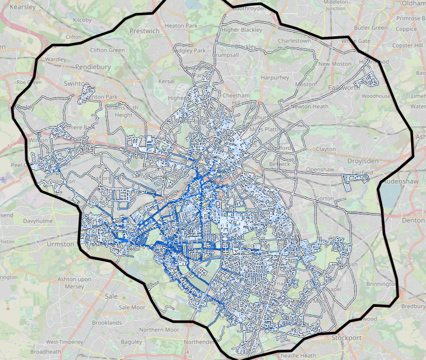
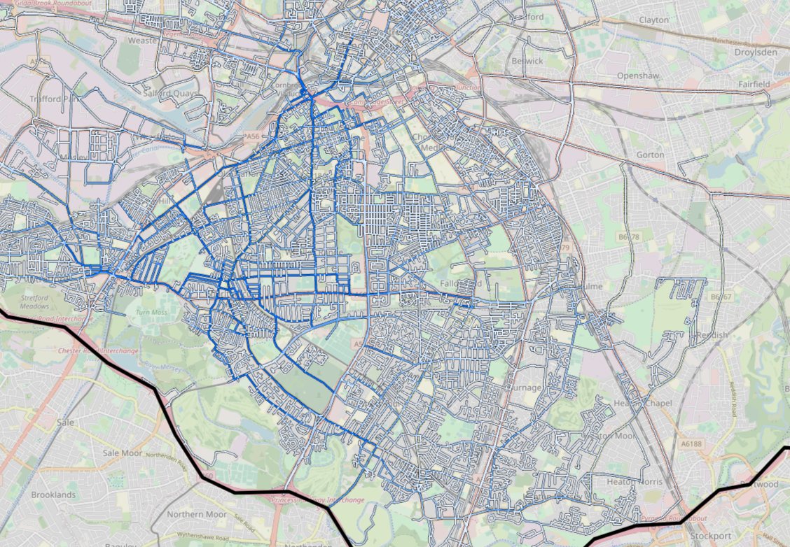
<p><strong>Progress April 2023 to mid July 2023: 43.09% -&gt; 44.66%</strong></p>

<table>
  <thead>
    <tr>
      <th style="text-align: center"><img src="/running_app/assets/images/spring-2023-progress/progress.png" alt="Progress up to and including 2023-07-16" /></th>
    </tr>
  </thead>
  <tbody>
    <tr>
      <td style="text-align: center"><em>Progress up to and including 2023-07-16, coloured by number of traversals.</em></td>
    </tr>
  </tbody>
</table>

<h3 id="run-1---2023-05-21">Run 1 - 2023-05-21</h3>

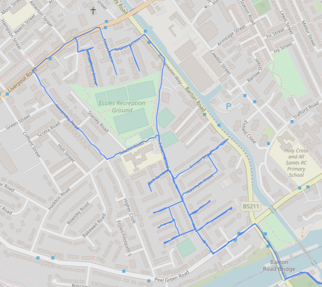
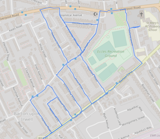
<p>First run adding new roads for almost 2 months, near Barton Road Bridge. I was last in this area on 2022-04-03 when I did some an estate to the west right next to the M60 boundary.</p>

<table>
  <thead>
    <tr>
      <th style="text-align: center"><img src="/running_app/assets/images/spring-2023-progress/2023-05-21.png" alt="Run on 2023-05-21" /></th>
    </tr>
  </thead>
  <tbody>
    <tr>
      <td style="text-align: center"><em>2023-05-21 run added 2.7km of new road, 43.20% total completion. Start and end along Bridgewater Canal not shown.</em></td>
    </tr>
  </tbody>
</table>

<h3 id="run-2---2023-05-28">Run 2 - 2023-05-28</h3>

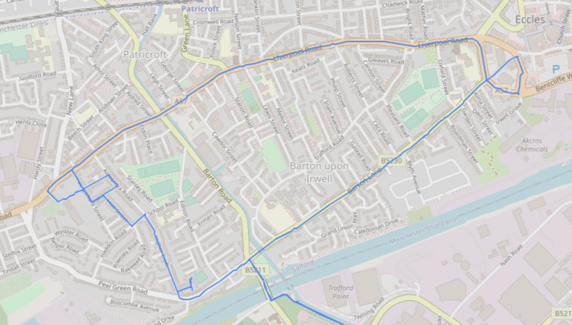
<p>Very close to the week before plus a longer loop up to Eccles town centre and back. I often do this for areas that I don’t know very well - run the main roads to form a mental map of the area prior to filling in the smaller roads in the near future.</p>

<table>
  <thead>
    <tr>
      <th style="text-align: center"><img src="/running_app/assets/images/spring-2023-progress/2023-05-28.png" alt="Run on 2023-05-28" /></th>
    </tr>
  </thead>
  <tbody>
    <tr>
      <td style="text-align: center"><em>2023-05-28 run added 3.4km of new road, 43.34% total completion. Start and end along Bridgewater Canal not shown.</em></td>
    </tr>
  </tbody>
</table>

<h3 id="run-3---2023-06-04">Run 3 - 2023-06-04</h3>

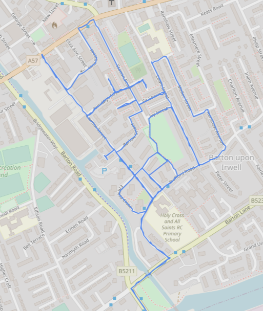
<p>Filling in an area right next to the canal within the long loop I ran the week prior.</p>

<table>
  <thead>
    <tr>
      <th style="text-align: center"><img src="/running_app/assets/images/spring-2023-progress/2023-06-04.png" alt="Run on 2023-06-04" /></th>
    </tr>
  </thead>
  <tbody>
    <tr>
      <td style="text-align: center"><em>2023-06-04 run added 3.4km of new road, 43.48% total completion. Start and end along Bridgewater Canal not shown.</em></td>
    </tr>
  </tbody>
</table>

<h3 id="run-4---2023-06-18">Run 4 - 2023-06-18</h3>

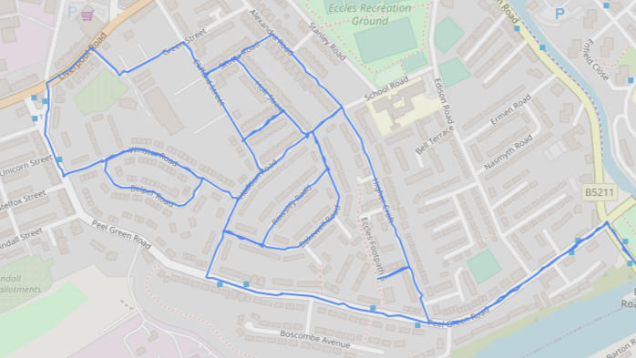
<p>Again, filling in more of the roads within the long loop to Eccles from 2023-05-28.</p>

<table>
  <thead>
    <tr>
      <th style="text-align: center"><img src="/running_app/assets/images/spring-2023-progress/2023-06-18.png" alt="Run on 2023-06-18" /></th>
    </tr>
  </thead>
  <tbody>
    <tr>
      <td style="text-align: center"><em>2023-06-18 run added 2.8km of new road, 43.59% total completion. Start and end along Bridgewater Canal not shown.</em></td>
    </tr>
  </tbody>
</table>

<h3 id="run-5---2023-06-25">Run 5 - 2023-06-25</h3>

<p>This time to the west of Barton Road Bridge, almost abutting the estate I had done in 2022 which is just in view on the extreme left of the image.</p>

<table>
  <thead>
    <tr>
      <th style="text-align: center"><img src="/running_app/assets/images/spring-2023-progress/2023-06-25.png" alt="Run on 2023-06-25" /></th>
    </tr>
  </thead>
  <tbody>
    <tr>
      <td style="text-align: center"><em>2023-06-25 run added 1.8km of new road, 43.67% total completion. Start and end along Bridgewater Canal not shown.</em></td>
    </tr>
  </tbody>
</table>

<h3 id="run-6---2023-07-02">Run 6 - 2023-07-02</h3>

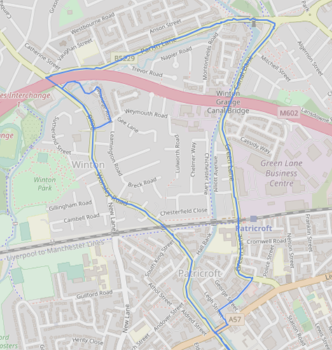
<p>A bit further afield from Barton Road Bridge through Patricroft and under the M602 twice.</p>

<table>
  <thead>
    <tr>
      <th style="text-align: center"><img src="/running_app/assets/images/spring-2023-progress/2023-07-02.png" alt="Run on 2023-07-02" /></th>
    </tr>
  </thead>
  <tbody>
    <tr>
      <td style="text-align: center"><em>2023-07-02 run added 3.5km of new road, 43.81% total completion. Start and end along Bridgewater Canal not shown.</em></td>
    </tr>
  </tbody>
</table>

<h3 id="run-7---2023-07-09">Run 7 - 2023-07-09</h3>

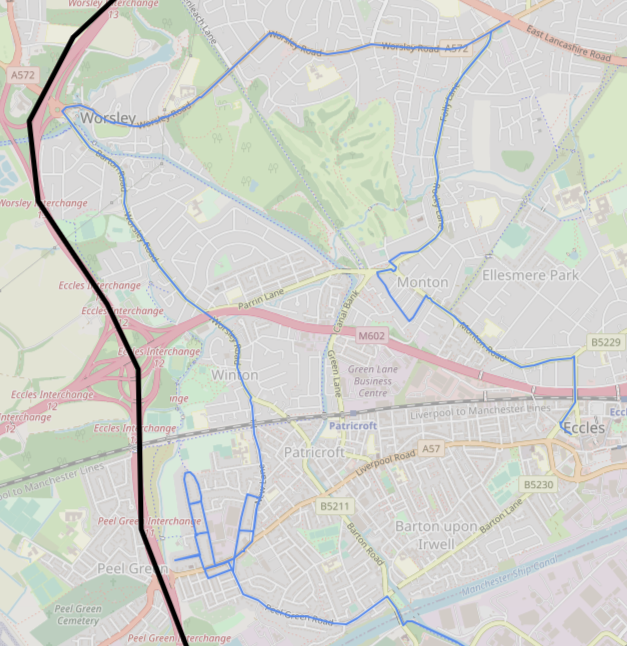
<p>A big loop through Winton, Worsley and Monton before ending in Eccles town centre near the tram stop. Other than Monton, which I had run through on 2021-08-18, all of this was unseen territory for me.</p>

<table>
  <thead>
    <tr>
      <th style="text-align: center"><img src="/running_app/assets/images/spring-2023-progress/2023-07-09.png" alt="Run on 2023-07-09" /></th>
    </tr>
  </thead>
  <tbody>
    <tr>
      <td style="text-align: center"><em>2023-07-09 run added 9.6km of new road, 44.21% total completion. Start along Bridgewater Canal not shown.</em></td>
    </tr>
  </tbody>
</table>

<h3 id="run-8---2023-07-16">Run 8 - 2023-07-16</h3>

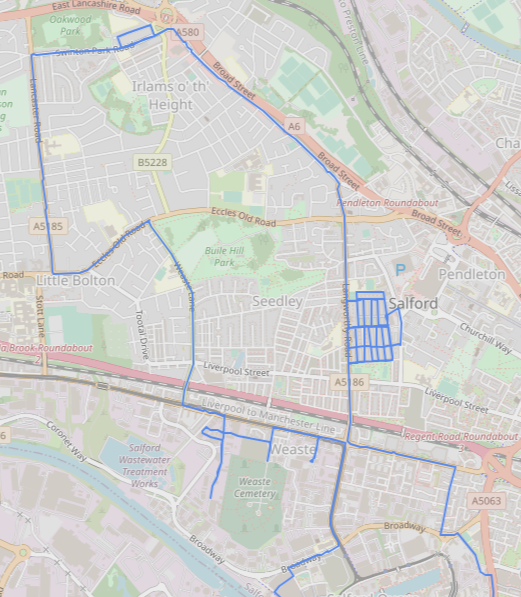
<p>Taking a break from going across the Barton Road Bridge, I went past Old Trafford into Salford with a view to running some of the main roads. I ended up doing a grid estate and some roads near Weaste tram stop that I hadn’t previously. One of which was an unpaved industrial road which I didn’t realise was a cul-de-sac!</p>

<table>
  <thead>
    <tr>
      <th style="text-align: center"><img src="/running_app/assets/images/spring-2023-progress/2023-07-16.png" alt="Run on 2023-07-16" /></th>
    </tr>
  </thead>
  <tbody>
    <tr>
      <td style="text-align: center"><em>2023-07-16 run added 10.9km of new road, 44.66% total completion. Start through Trafford not shown.</em></td>
    </tr>
  </tbody>
</table>]]></content><author><name></name></author><category term="update" /><summary type="html"><![CDATA[A belated update after a bit of a break post-Manchester marathon. I decided to switch up areas from Levenshulme/Reddish earlier in the year to Eccles and Salford. For the most part I used a spur of the Bridgewater Canal to get to the Barton Road Bridge, which takes 30-40 minutes in each direction.]]></summary></entry><entry><title type="html">March 2023 progress</title><link href="https://minimav.github.io/running_app/update/2023/03/26/march-2023-progress.html" rel="alternate" type="text/html" title="March 2023 progress" /><published>2023-03-26T13:00:00+00:00</published><updated>2023-03-26T13:00:00+00:00</updated><id>https://minimav.github.io/running_app/update/2023/03/26/march-2023-progress</id><content type="html" xml:base="https://minimav.github.io/running_app/update/2023/03/26/march-2023-progress.html"><![CDATA[<p>I ran a 10k race at the start of March which meant a first long run nearly halfway through the month. However, I was in the middle of marathon training, which meant that long runs were longer than usual, with plenty of opportunity to run new roads.</p>

<p><strong>Progress this month: 41.84% -&gt; 43.09%</strong></p>

<h3 id="run-1---2023-03-12">Run 1 - 2023-03-12</h3>

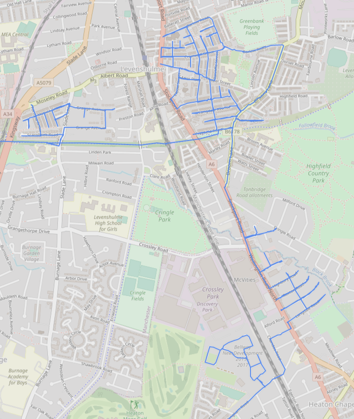
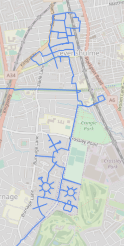
<p>For my first run this month I once again used the Fallowfield Loop at the start of the run and ended at East Didsbury tram stop. My focus here was in three locations:</p>

<ol>
  <li>Cleaning up a small collection of roads near to the roundabout at the top of Kingsway which I’d missed previously.</li>
  <li>Completing some roads just east of Stockport Road in the heart of Levenshulme.</li>
  <li>Some more roads east of Stockport Road slightly south of Levenshulme, which are in an easy to remember configuration.</li>
</ol>

<p>I ended up also doing a small new-build estate on the way to the tram stop at the end of the run.</p>

<p>Usually I roughly plan which roads I’m going to run, but on longer runs it is very easy to lose my bearings (and looking at a map is cheating!). Splitting up the run into these three sections, which you can see below, helps with remembering where to go immensely.</p>

<table>
  <thead>
    <tr>
      <th style="text-align: center"><img src="/running_app/assets/images/march-2023-progress/2023-03-12.png" alt="Run on 2023-03-12" /></th>
    </tr>
  </thead>
  <tbody>
    <tr>
      <td style="text-align: center"><em>2023-03-12 run added 9.8km of new road, 42.27% total completion. Start on Fallowfield Loop and end at East Didsbury tram stop not shown.</em></td>
    </tr>
  </tbody>
</table>

<h3 id="run-2---2023-03-19">Run 2 - 2023-03-19</h3>

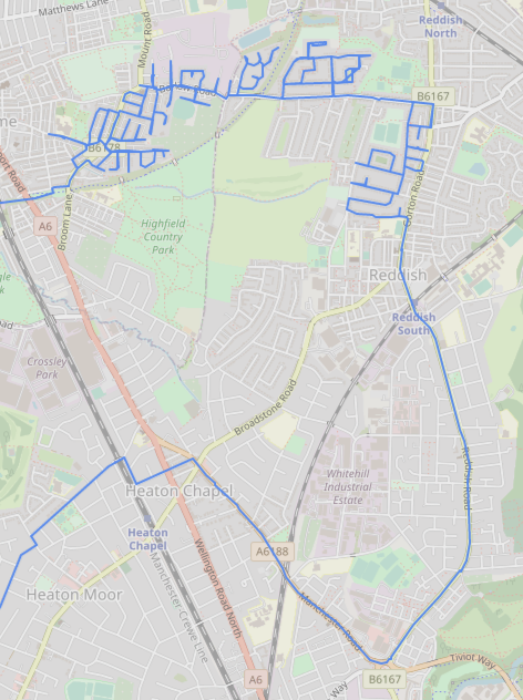
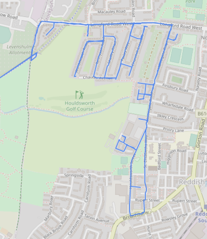
<p>This was the second longest run of my marathon training, with a total length of ~30km. In this run my aim was to clean up a few roads near to last week’s run, then complete roads to the east of Broom Lane between the Fallowfield Loop in the south and Barlow Road in the north.</p>

<p>After that I did some roads north of Longford Road West – complementing ones I did last month to the south of it – then followed Reddish Road and eventually Manchester Road. I’d intended to exit the big roundabout onto Belmont Way but lost my bearings and ended up running more north-west than I had planned.</p>

<table>
  <thead>
    <tr>
      <th style="text-align: center"><img src="/running_app/assets/images/march-2023-progress/2023-03-19.png" alt="Run on 2023-03-19" /></th>
    </tr>
  </thead>
  <tbody>
    <tr>
      <td style="text-align: center"><em>2023-03-19 run added 13.7km of new road, 42.84% total completion. Start on Fallowfield Loop and end at East Didsbury tram stop not shown.</em></td>
    </tr>
  </tbody>
</table>

<h3 id="run-3---2023-03-26">Run 3 - 2023-03-26</h3>

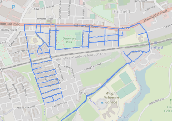
<p>This was the longest run of marathon training, about 2 hours 45 minutes in duration. I ran the whole length of the Fallowfield Loop both outwards and back, which is ~14 miles. In between I did some roads in Fairfield, an area which I’ve hardly touched so far.</p>

<p>The grid pattern of roads that I ran in Fairfield is one that makes remembering the route very easy.</p>

<table>
  <thead>
    <tr>
      <th style="text-align: center"><img src="/running_app/assets/images/march-2023-progress/2023-03-26.png" alt="Run on 2023-03-26" /></th>
    </tr>
  </thead>
  <tbody>
    <tr>
      <td style="text-align: center"><em>2023-03-26 run added 6.0km of new road, 43.09% total completion. Start and end on Fallowfield Loop not shown.</em></td>
    </tr>
  </tbody>
</table>]]></content><author><name></name></author><category term="update" /><summary type="html"><![CDATA[I ran a 10k race at the start of March which meant a first long run nearly halfway through the month. However, I was in the middle of marathon training, which meant that long runs were longer than usual, with plenty of opportunity to run new roads.]]></summary></entry><entry><title type="html">My favourite roads so far</title><link href="https://minimav.github.io/running_app/top-list/2023/03/12/my-favourite-roads-so-far.html" rel="alternate" type="text/html" title="My favourite roads so far" /><published>2023-03-12T17:00:00+00:00</published><updated>2023-03-12T17:00:00+00:00</updated><id>https://minimav.github.io/running_app/top-list/2023/03/12/my-favourite-roads-so-far</id><content type="html" xml:base="https://minimav.github.io/running_app/top-list/2023/03/12/my-favourite-roads-so-far.html"><![CDATA[<p>Most roads are quite boring, which is not exactly a hot take. However, some roads are more interesting than others, for a variety of reasons. Having run an awful lot of them so far, certain ones still stick in my mind. Here is a list of them in no particular order.</p>

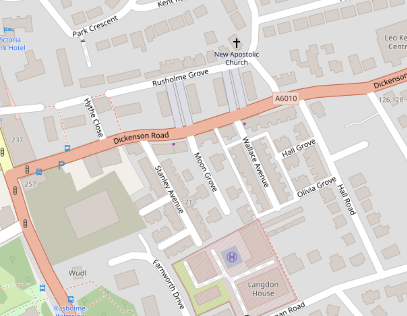
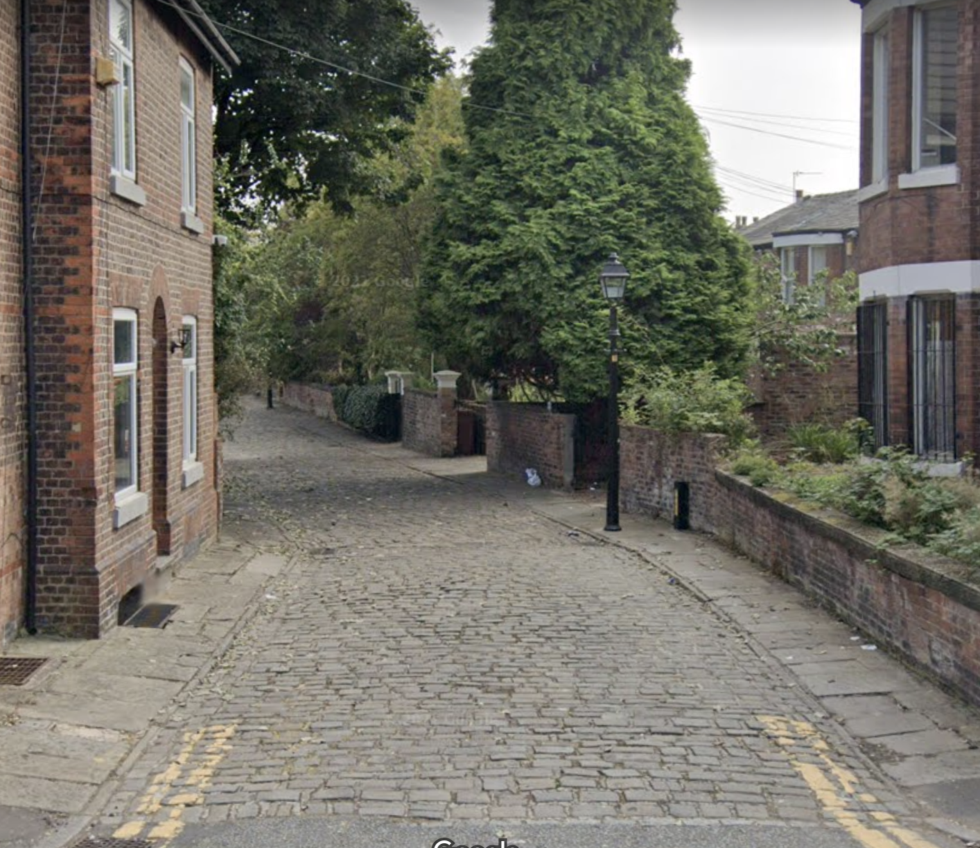
<h3 id="1-moon-grove-rusholme">1. Moon Grove, Rusholme</h3>

<p>This is a lovely little cobbled cul-de-sac only 30 seconds from the Curry Mile in Rusholme. I enjoyed this one because it was so unexpected in that part of the city, I’d probably not have given it as much attention had it been further south in the suburbs.</p>

<table>
  <thead>
    <tr>
      <th style="text-align: center"><img src="/running_app/assets/images/my-favourite-roads-so-far/moon_grove_osm.png" alt="Moon Grove, Rusholme on OSM" /></th>
    </tr>
  </thead>
  <tbody>
    <tr>
      <td style="text-align: center"><em>Moon Grove, incongrously nestled away just east of the Curry Mile. (<a href="openstreetmap.org/copyright">OpenStreetMap</a>)</em></td>
    </tr>
  </tbody>
</table>

<p>Unfortunately Street View doesn’t quite do it justice but hopefully it gives a glimpse of its charm:</p>

<table>
  <thead>
    <tr>
      <th style="text-align: center"><img src="/running_app/assets/images/my-favourite-roads-so-far/moon_grove_street_view.png" alt="Moon Grove, Rusholme on Street View" /></th>
    </tr>
  </thead>
  <tbody>
    <tr>
      <td style="text-align: center"><em>Entrance to Moon Grove via Google Street View. (<a href="https://www.google.com/maps/@53.452332,-2.2194485,3a,34.5y,166.94h,87.1t/data=!3m6!1e1!3m4!1se4P0GFBHeN29siNhGbb28w!2e0!7i16384!8i8192">© 2023 Google</a>)</em></td>
    </tr>
  </tbody>
</table>

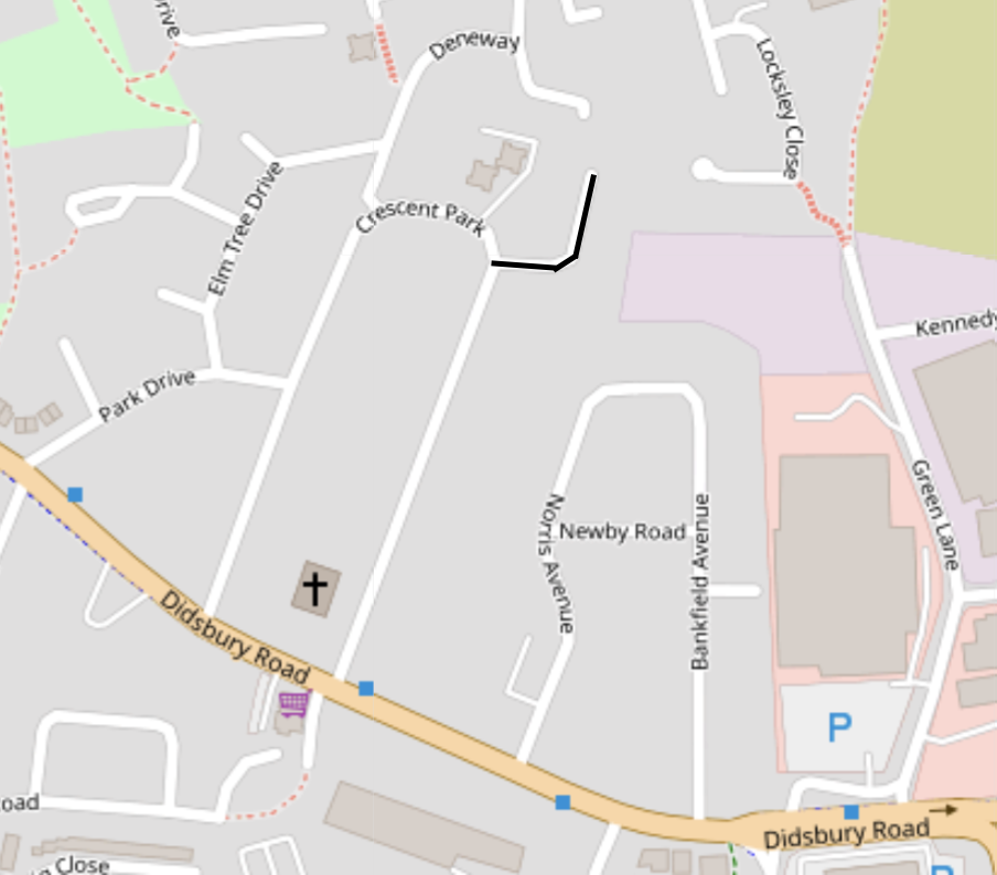
<h3 id="2-st-martins-avenue-heaton-norris">2. St. Martin’s Avenue, Heaton Norris</h3>

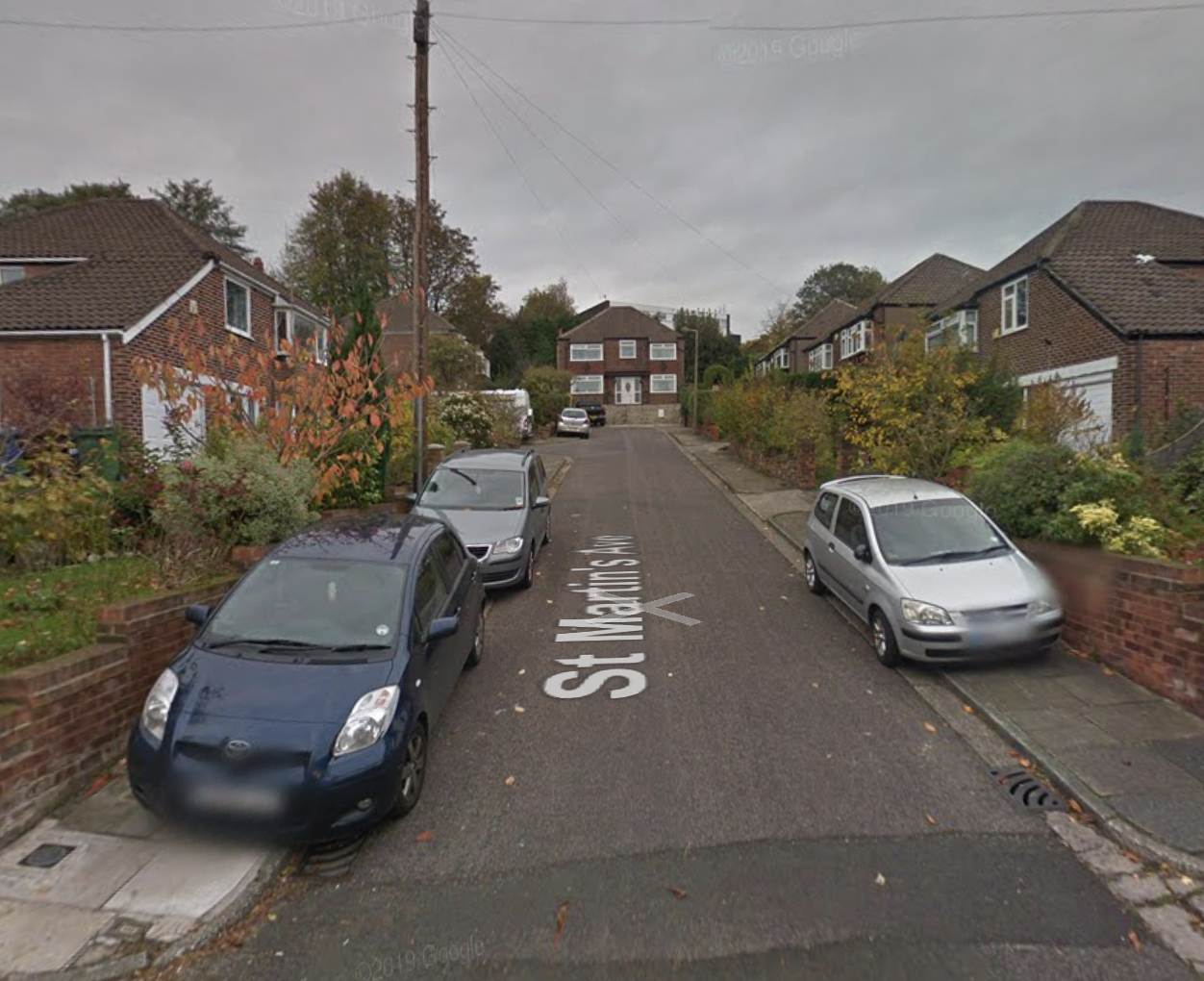
<p>Another cul-de-sac, this one  very steep. Reaching the end of this road felt like an achievement and also had the feeling of being in an ampitheatre.</p>

<table>
  <thead>
    <tr>
      <th style="text-align: center"><img src="/running_app/assets/images/my-favourite-roads-so-far/st_martins_avenue_osm.png" alt="St. Martins' Avenue, Heaton Norris on OSM" /></th>
    </tr>
  </thead>
  <tbody>
    <tr>
      <td style="text-align: center"><em>St. Martin’s Avenue, a cul-de-sac just north of Didsbury Road connecting East Didsbury and Stockport. (<a href="openstreetmap.org/copyright">OpenStreetMap</a>)</em></td>
    </tr>
  </tbody>
</table>

<p>The run on which I completed this road was unexpectedly hilly.</p>

<table>
  <thead>
    <tr>
      <th style="text-align: center"><img src="/running_app/assets/images/my-favourite-roads-so-far/st_martins_avenue_street_view.png" alt="St. Martins' Avenue, Heaton Norris on Street View" /></th>
    </tr>
  </thead>
  <tbody>
    <tr>
      <td style="text-align: center"><em>St. Martin’s Avenue via Google Street View. Far more steep that this picture suggests! (<a href="https://www.google.com/maps/@53.4128351,-2.1790227,3a,85.5y,15.75h,87.62t/data=!3m6!1e1!3m4!1souY-8eeHhVl1webyQfzQ2Q!2e0!7i13312!8i6656">© 2023 Google</a>)</em></td>
    </tr>
  </tbody>
</table>

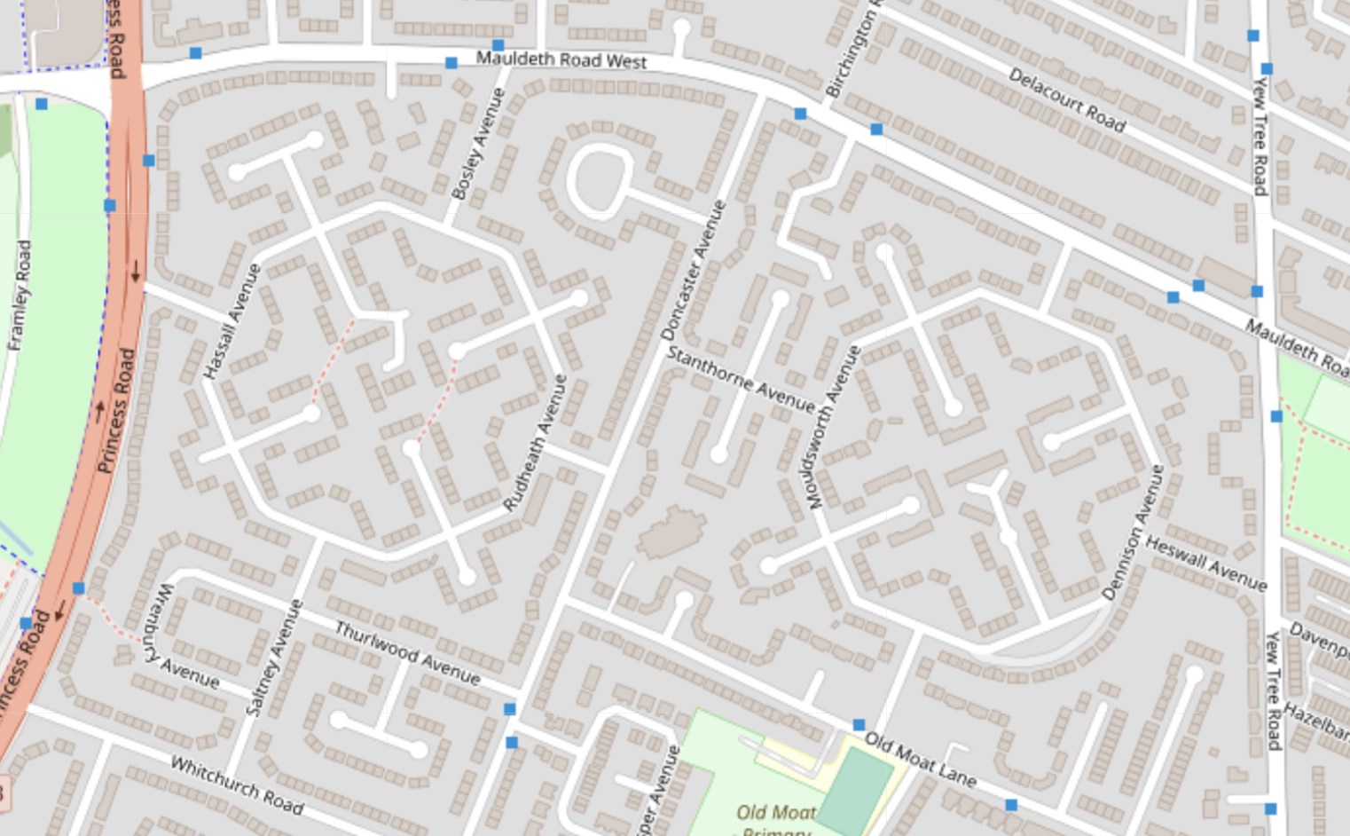
<h3 id="3-octagonal-avenues-withington">3. Octagonal avenues, Withington</h3>

<p>Hassall, Rudheath, Mouldsworth and Dennison Avenue comprise two distinctive octagons in Withington:</p>

<table>
  <thead>
    <tr>
      <th style="text-align: center"><img src="/running_app/assets/images/my-favourite-roads-so-far/octagonal_roads_osm.png" alt="Octagonal roads in Withington on OSM" /></th>
    </tr>
  </thead>
  <tbody>
    <tr>
      <td style="text-align: center"><em>Octagonal roads in Withington. (<a href="openstreetmap.org/copyright">OpenStreetMap</a>)</em></td>
    </tr>
  </tbody>
</table>

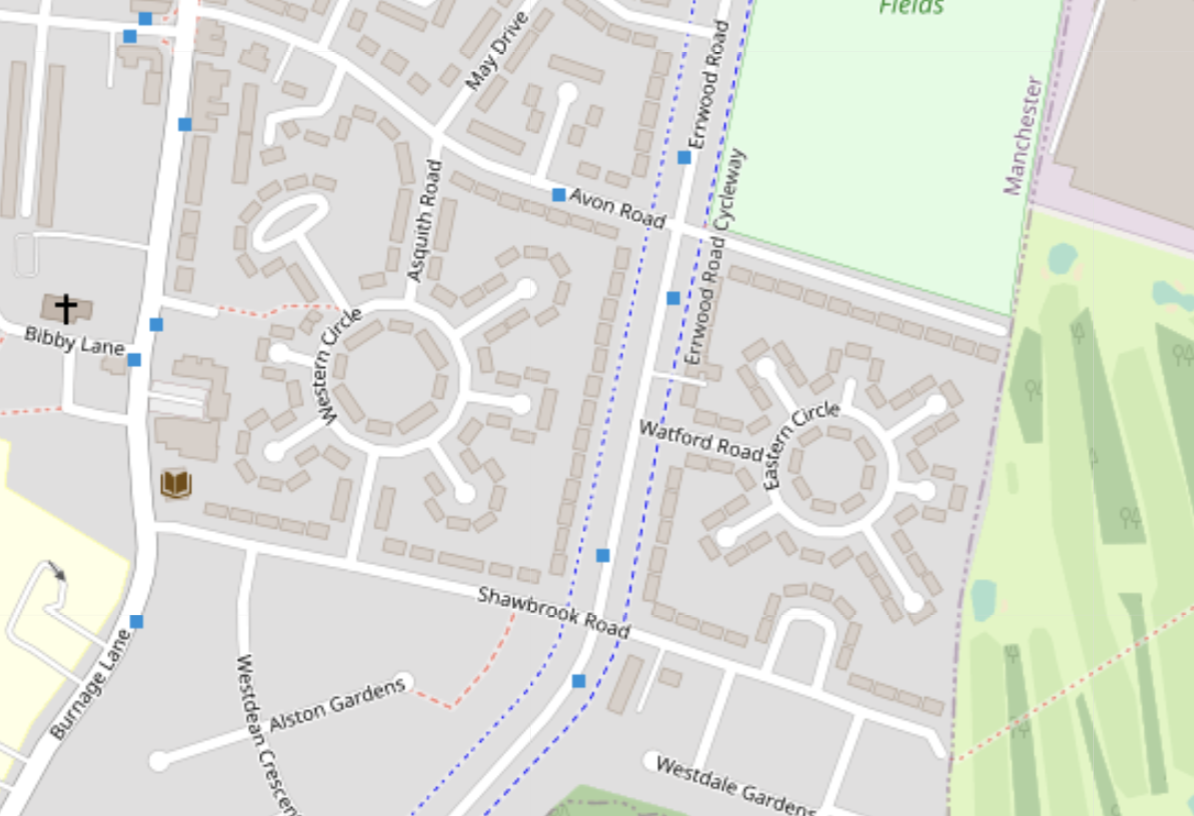
<p>These roads make the list purely because the pattern they create is so distinctive. Honourable mention to these very similar circular roads in Burnage:</p>

<table>
  <thead>
    <tr>
      <th style="text-align: center"><img src="/running_app/assets/images/my-favourite-roads-so-far/circular_roads_osm.png" alt="Circular roads in Burnage on OSM" /></th>
    </tr>
  </thead>
  <tbody>
    <tr>
      <td style="text-align: center"><em>Circular roads in Burnage. (<a href="openstreetmap.org/copyright">OpenStreetMap</a>)</em></td>
    </tr>
  </tbody>
</table>

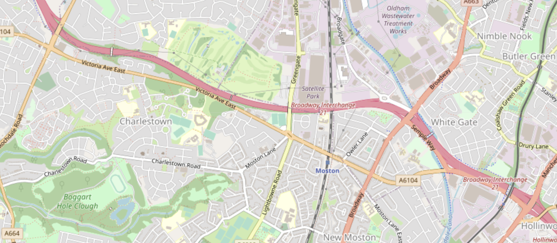
<h3 id="4-victoria-avenue-east-north-manchester">4. Victoria Avenue East, North Manchester</h3>

<p>I ran Victoria Avenue East on the run with the most new distance so far, 23.3km, on 13th December 2020. I remember it was a horrible, drizzly day. I ran out of the city centre along Oldham Road till it meets the M60, then along the full length of Victoria Avenue East in a westerly direction until Heaton Park, before meandering back to the city centre.</p>

<table>
  <thead>
    <tr>
      <th style="text-align: center"><img src="/running_app/assets/images/my-favourite-roads-so-far/victoria_avenue_east_osm.png" alt="Victoria Avenue East on OSM" /></th>
    </tr>
  </thead>
  <tbody>
    <tr>
      <td style="text-align: center"><em>Victoria Avenue East – the main west-east orange road – which continues off the left of the image to Heaton Park. (<a href="openstreetmap.org/copyright">OpenStreetMap</a>)</em></td>
    </tr>
  </tbody>
</table>

<p>I enjoy these long straight roads with relatively few junctions for their length. Aside from this I also have good memories because I walked along it in 2015 when I completed the <a href="https://en.wikipedia.org/wiki/Bogle_Stroll">Bogle Stroll</a>, a 55-mile charity walk. The Bogle route is a rough figure of 8 with one loop in south Manchester and the other, which includes this road, in the north.</p>

<h3 id="5-ten-acres-lane-near-clayton-value-east-manchester">5. Ten Acres Lane, near Clayton Value, East Manchester</h3>

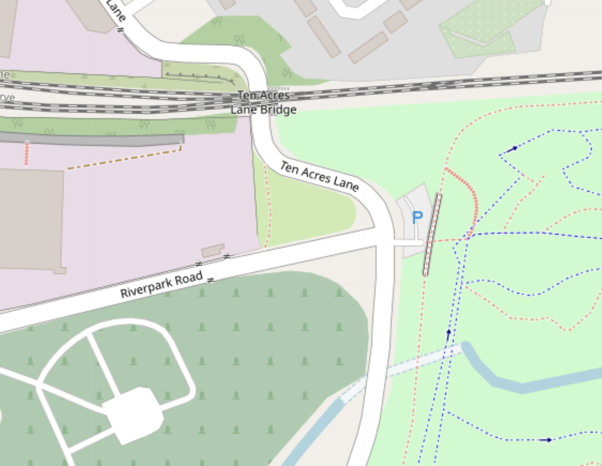
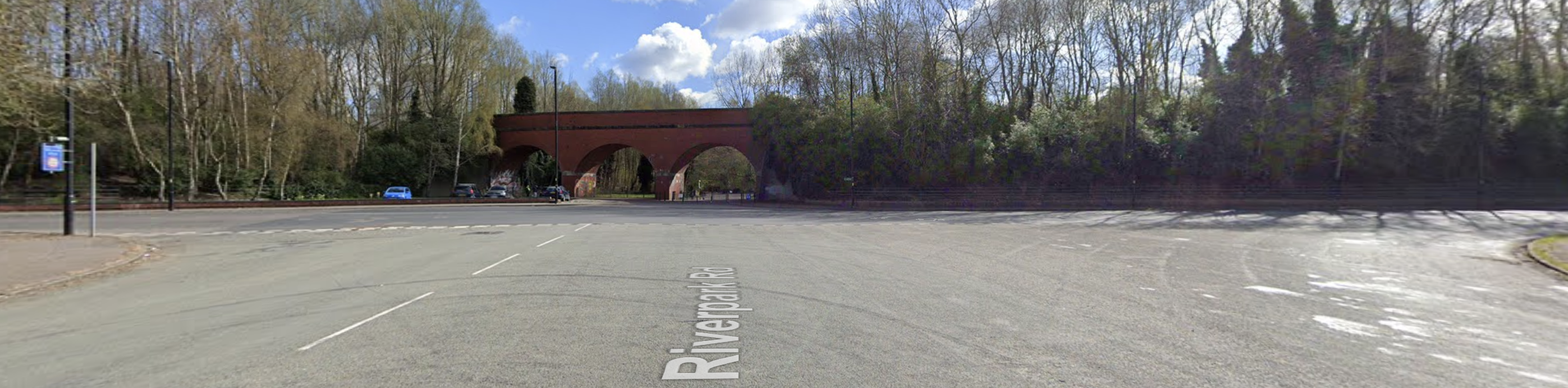
<p>I ran this road on 20th September 2020 when meandering somewhat aimlessly in East Manchester not too far from Manchester City’s stadium. It was pure chance that I ended up on this winding road. From just looking on a map it looks fairly non-descript, however the interesting bit was the junction with Riverpark Road:</p>

<table>
  <thead>
    <tr>
      <th style="text-align: center"><img src="/running_app/assets/images/my-favourite-roads-so-far/ten_acres_lane_osm.png" alt="Ten Acres Lane on OSM" /></th>
    </tr>
  </thead>
  <tbody>
    <tr>
      <td style="text-align: center"><em>Ten Acres Lane, in particular the junction with Riverpark Road. (<a href="openstreetmap.org/copyright">OpenStreetMap</a>)</em></td>
    </tr>
  </tbody>
</table>

<p>This junction is really, really wide, especially considering that it’s probably not that busy a road.</p>

<table>
  <thead>
    <tr>
      <th style="text-align: center"><img src="/running_app/assets/images/my-favourite-roads-so-far/ten_acres_lane_street_view.png" alt="Riverpark Road junction with Ten Acres Lane on Street View" /></th>
    </tr>
  </thead>
  <tbody>
    <tr>
      <td style="text-align: center"><em>Junction of Riverpark Road and Ten Acres Lane. Wide, very wide. (<a href="https://www.google.com/maps/@53.4914955,-2.1865744,3a,75y,88.72h,89.99t/data=!3m6!1e1!3m4!1s1_sXv3rpYVAmH7llzENvpQ!2e0!7i16384!8i8192">© 2023 Google</a>)</em></td>
    </tr>
  </tbody>
</table>

<p>Extra points for the bridge over the entrance to Clayton Vale. This road remains one of the furthest into Clayton and Droylesden that I’ve completed.</p>

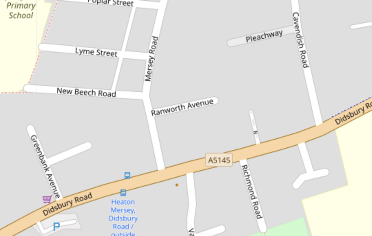
<h3 id="6-any-residential-street-with-a-cherry-blossom">6. Any residential street with a cherry blossom</h3>

<p>A cherry blossom tree during summer elevates any street. Ranworth Avenue is just one example that I remember. I ran along Mersey Road again recently (during winter) and it looked like any other residential cul-de-sac.</p>

<table>
  <thead>
    <tr>
      <th style="text-align: center"><img src="/running_app/assets/images/my-favourite-roads-so-far/ranworth_avenue_osm.png" alt="Ranworth Avenue on OSM" /></th>
    </tr>
  </thead>
  <tbody>
    <tr>
      <td style="text-align: center"><em>Ranworth Avenue, just north of Didsbury road connecting East Didsbury and Stockport. (<a href="openstreetmap.org/copyright">OpenStreetMap</a>)</em></td>
    </tr>
  </tbody>
</table>]]></content><author><name></name></author><category term="top-list" /><summary type="html"><![CDATA[Most roads are quite boring, which is not exactly a hot take. However, some roads are more interesting than others, for a variety of reasons. Having run an awful lot of them so far, certain ones still stick in my mind. Here is a list of them in no particular order.]]></summary></entry><entry><title type="html">February 2023 progress</title><link href="https://minimav.github.io/running_app/update/2023/02/26/feb-2023-progress.html" rel="alternate" type="text/html" title="February 2023 progress" /><published>2023-02-26T15:00:00+00:00</published><updated>2023-02-26T15:00:00+00:00</updated><id>https://minimav.github.io/running_app/update/2023/02/26/feb-2023-progress</id><content type="html" xml:base="https://minimav.github.io/running_app/update/2023/02/26/feb-2023-progress.html"><![CDATA[<p>I haven’t made much progress over the last few months. In part this was due to getting Covid in August 2022, which meant that I didn’t do as much running during Autumn and Winter. But even when fit, it now takes a while to get anywhere with new roads, even with public transport! Nevertheless, I had a couple of weeks off work this month that enabled me to go on some long runs, and that gave me more motivation to continue as part of regular weekly long runs.</p>

<p>I’ve slowly been expanding eastwards into Levenshulme, and this was the area that I focused on during these runs. One reason for this is that the <a href="https://fallowfieldloop.org/">Fallowfield Loop</a> bike path goes from Chorlton, where I’m based, directly east for several miles before turning north and ending up in Fairfield in East Manchester. It’s a great way to cover distance to new roads without having to deal with cars.</p>

<p><strong>Progress this month: 40.71% -&gt; 41.84%</strong></p>

<p>I made some changes to the stats page as well, including changing the colour gradient when plotting the number of traversals per segment. This distribution is very skewed towards most segments only having one traversal, thus defining the colour gradient is not straightforward. After a bit of fiddling about I got the following output:</p>

<table>
  <thead>
    <tr>
      <th style="text-align: center"><img src="/running_app/assets/images/feb-2023-progress/colour-gradient.png" alt="# traversals per segment" /></th>
    </tr>
  </thead>
  <tbody>
    <tr>
      <td style="text-align: center"><em>New colour gradient for plotting the number of traversals per segment.</em></td>
    </tr>
  </tbody>
</table>

<h3 id="run-1---2023-02-06">Run 1 - 2023-02-06</h3>

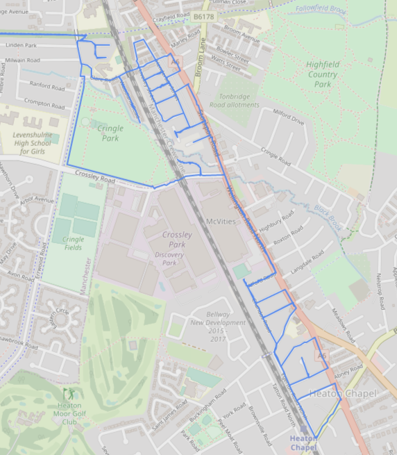
<p>For my first run, on 6th February, I used the Fallowfield Loop both at the start and end of my run. This covered ~8 miles, leaving about 40 minutes of pootling about around Levenshulme in which to add new roads. I did a minor bit of non-challenge distance aside from the Fallowfield Loop via a short stretch through Cringle Park.</p>

<table>
  <thead>
    <tr>
      <th style="text-align: center"><img src="/running_app/assets/images/feb-2023-progress/2023-02-06.png" alt="Run on 2023-02-06" /></th>
    </tr>
  </thead>
  <tbody>
    <tr>
      <td style="text-align: center"><em>2023-02-06 run added 4.11km of new road, 40.88% total completion. Start and end on Fallowfield Loop not shown.</em></td>
    </tr>
  </tbody>
</table>

<p>One of the best parts of running in this area is the huge McVities factory alongside Wellington Road North (A6). There are some lovely biscuity smells to enjoy on certain roads in the vicinity of the factory.</p>

<h3 id="run-2---2023-02-14">Run 2 - 2023-02-14</h3>

<p>For the next run, on 14th February, I again used the Fallowfield Loop at the start of the run, but ran south at the end to East Didsbury tram stop. Doing this meant I could spend more of the run doing new roads rather than getting to and from home. East Didsbury tram stop is probably the ‘best’ remaining tram stop available to me in terms of minimising travel distance, while still being relatively close to new roads.</p>

<table>
  <thead>
    <tr>
      <th style="text-align: center"><img src="/running_app/assets/images/feb-2023-progress/2023-02-14.png" alt="Run on 2023-02-14" /></th>
    </tr>
  </thead>
  <tbody>
    <tr>
      <td style="text-align: center"><em>2023-02-14 run added 6.55km of new road, 41.15% total completion. Start on Fallowfield Loop and end at East Didsbury tram stop not shown.</em></td>
    </tr>
  </tbody>
</table>

<p>I did some interesting radial roads in this runs, as well as seeing a well-endowed sex toy in the middle of one street…</p>

<h3 id="run-3---2023-02-19">Run 3 - 2023-02-19</h3>

<p>Trying to get long runs back to weekends after my time off work, only a few days later I did another long run, this time into Reddish. I ran slightly further along the Fallowfield Loop before exiting it, into a part of Manchester that I barely know at all.</p>

<table>
  <thead>
    <tr>
      <th style="text-align: center"><img src="/running_app/assets/images/feb-2023-progress/2023-02-19.png" alt="Run on 2023-02-19" /></th>
    </tr>
  </thead>
  <tbody>
    <tr>
      <td style="text-align: center"><em>2023-02-19 run added 5.35km of new road, 41.37% total completion. Start and end on Fallowfield Loop not shown.</em></td>
    </tr>
  </tbody>
</table>

<p>I got more biscuity smells on this run, albeit briefly. Also some nice old mill buildings in Reddish.</p>

<h3 id="run-4---2023-02-26">Run 4 - 2023-02-26</h3>

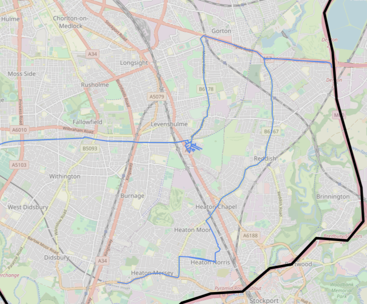
<p>For this run I completed a small collection of roads just east of the main road in Levenshulme, then did some long straight running in Gorton and Reddish, including going up to the eastern section of the M60. This type of run is quite useful to do when running in a new area that is unknown to me, as it gives me a ‘lie of the land’ that helps for more intricate future navigation.</p>

<table>
  <thead>
    <tr>
      <th style="text-align: center"><img src="/running_app/assets/images/feb-2023-progress/2023-02-26.png" alt="Run on 2023-02-26" /></th>
    </tr>
  </thead>
  <tbody>
    <tr>
      <td style="text-align: center"><em>2023-02-26 run added 11.4km of new road, 41.84% total completion. Start on Fallowfield Loop not shown.</em></td>
    </tr>
  </tbody>
</table>

<p>Once again I started along the Fallowfield Loop (warm-up?!) and finished at East Didsbury tram stop. The total run distance was just over 16 miles.</p>]]></content><author><name></name></author><category term="update" /><summary type="html"><![CDATA[I haven’t made much progress over the last few months. In part this was due to getting Covid in August 2022, which meant that I didn’t do as much running during Autumn and Winter. But even when fit, it now takes a while to get anywhere with new roads, even with public transport! Nevertheless, I had a couple of weeks off work this month that enabled me to go on some long runs, and that gave me more motivation to continue as part of regular weekly long runs.]]></summary></entry><entry><title type="html">Introduction</title><link href="https://minimav.github.io/running_app/update/2023/02/18/introduction.html" rel="alternate" type="text/html" title="Introduction" /><published>2023-02-18T13:00:00+00:00</published><updated>2023-02-18T13:00:00+00:00</updated><id>https://minimav.github.io/running_app/update/2023/02/18/introduction</id><content type="html" xml:base="https://minimav.github.io/running_app/update/2023/02/18/introduction.html"><![CDATA[<p>During the initial 2020 Covid lockdown I decided that running would be a good way to be able to see slightly more of the world than the just inside of my tiny flat. Even before the pandemic I had a habit of running the same old routes all the time.</p>

<p>Inspired by <a href="https://www.youtube.com/watch?v=jy_W5qsjB5U">Every Single Street with Rickey Gates</a>, I came up with the idea to try to run all streets within the M60 ring road around Manchester.</p>

<table>
  <thead>
    <tr>
      <th style="text-align: center"><img src="/running_app/assets/images/m60_sign.svg" alt="M60 sign" /></th>
    </tr>
  </thead>
  <tbody>
    <tr>
      <td style="text-align: center"><em>Standard UK road sign for the M60 motorway/ring road</em></td>
    </tr>
  </tbody>
</table>

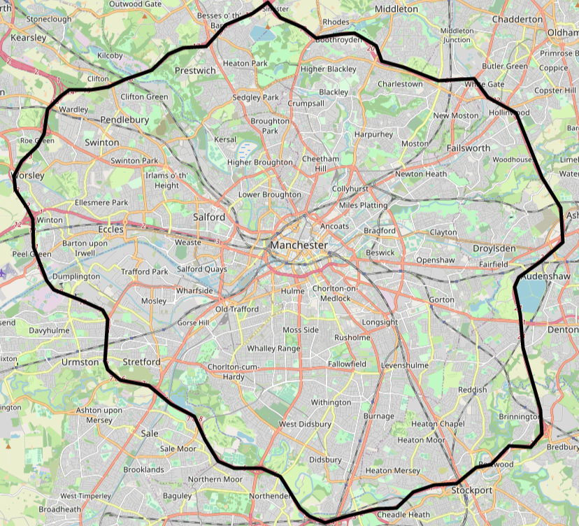
<p>Why the M60? Good question. At the time I was living in central Manchester and the ring road seemed to provided the best ‘natural’ bounded area to focus on. While the Mancunian Way (major red road below Manchester text in the image below) does potentially form part of a smaller ring around the city centre, it would not cover enough roads for the challenge to be fun. Using borough boundaries was also a possibility, just one that I didn’t consider at the time!</p>

<table>
  <thead>
    <tr>
      <th style="text-align: center"><img src="/running_app/assets/images/m60_leaflet.png" alt="M60 geometry" /></th>
    </tr>
  </thead>
  <tbody>
    <tr>
      <td style="text-align: center"><em>The M60 in all its majesty. (<a href="openstreetmap.org/copyright">OpenStreetMap</a>)</em></td>
    </tr>
  </tbody>
</table>

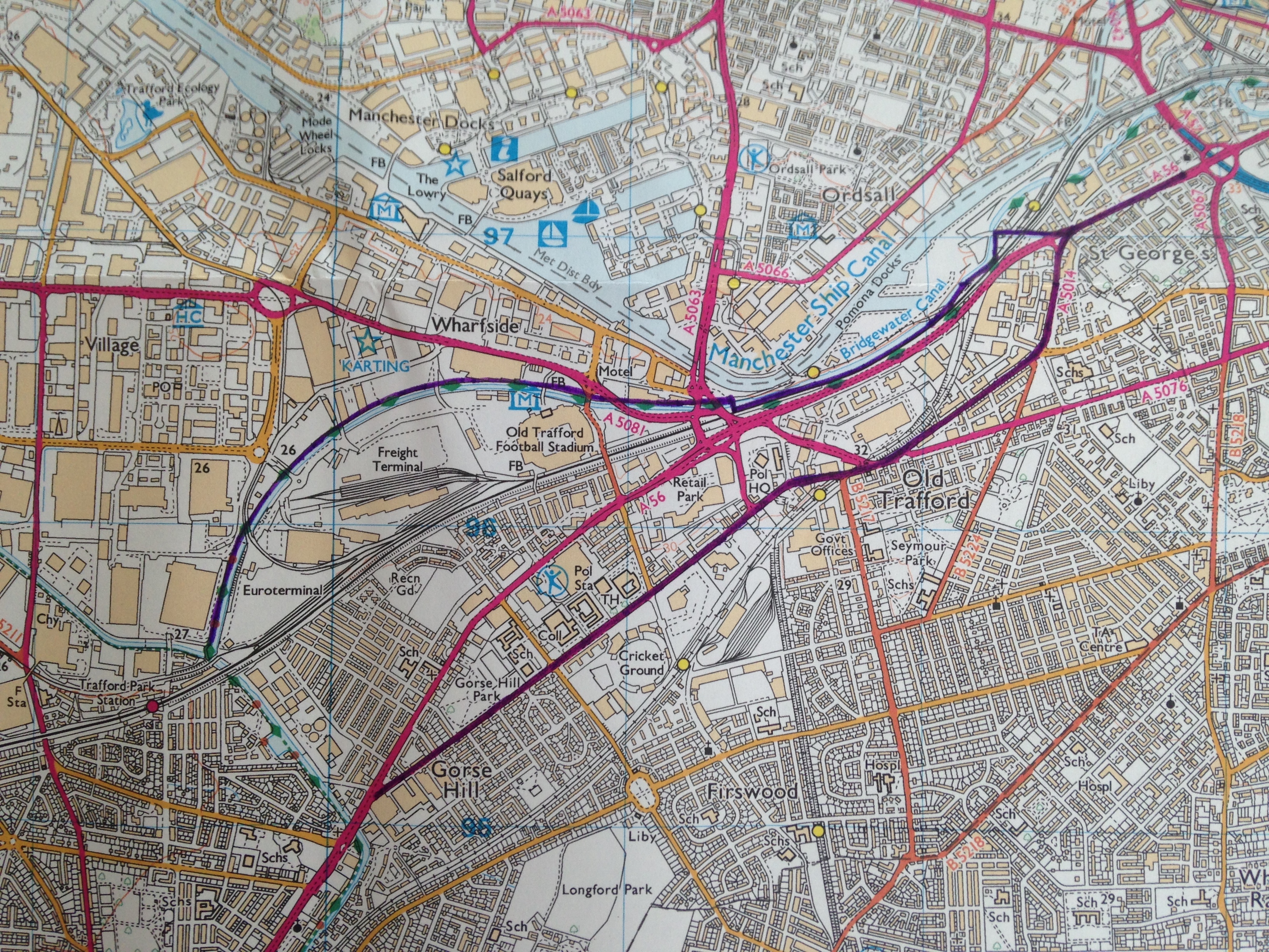
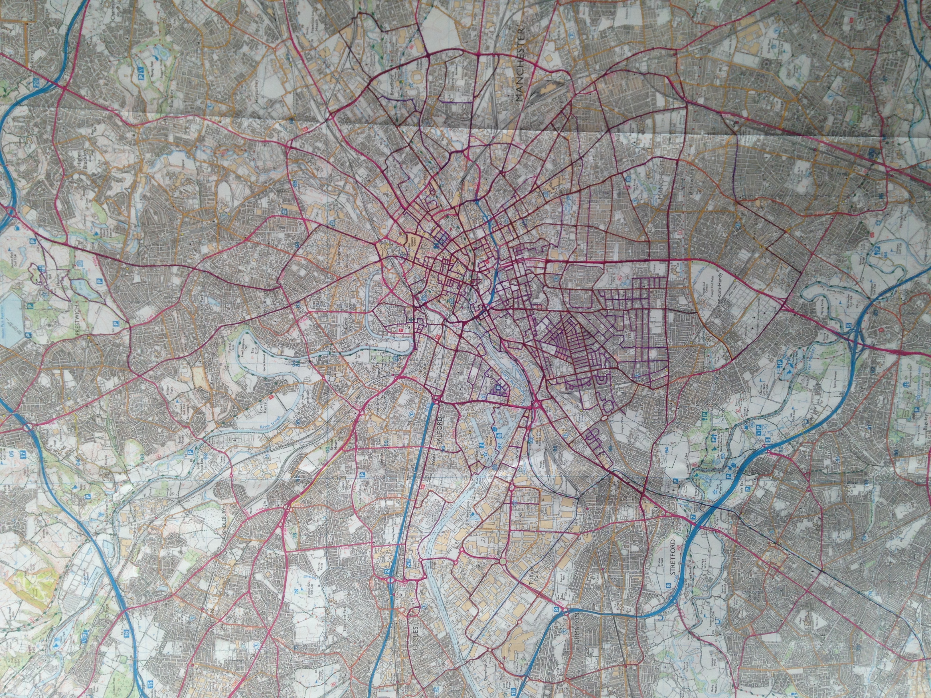
<p>The next question was how to track progress. Initially I wanted to keep things very low-tech and bought an Ordnance Survey (OS) map (<a href="https://shop.ordnancesurvey.co.uk/map-of-manchester-salford/">OS explorer 277</a>) that I updated with progress.</p>

<table>
  <thead>
    <tr>
      <th style="text-align: center"><img src="/running_app/assets/images/introduction/first_runs.JPG" alt="First runs on Ordnance Survey map" /></th>
    </tr>
  </thead>
  <tbody>
    <tr>
      <td style="text-align: center"><em>Ordnance Survey map that I use to track progress. This photo is from the very birth of the project after only 2 runs (June 2020). One run goes along the Bridgewater Canal, the other past Old Trafford cricket ground.</em></td>
    </tr>
  </tbody>
</table>

<table>
  <thead>
    <tr>
      <th style="text-align: center"><img src="/running_app/assets/images/introduction/few_months_progress.JPG" alt="Progress after a few months" /></th>
    </tr>
  </thead>
  <tbody>
    <tr>
      <td style="text-align: center"><em>Progress after a few months in September 2020. Most progress around the city centre and Old Trafford area, with some longer runs, including one outside the M60(!) along the Bridgewater Canal to Altrincham.</em></td>
    </tr>
  </tbody>
</table>

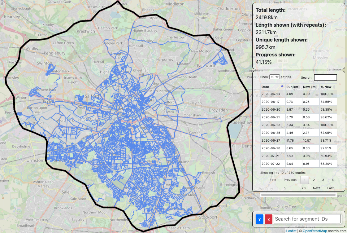
<p>As 2020 continued I began to think about more advanced ways to track progress. There are existing solutions for this e.g. <a href="http://www.everystreetchallenge.com/">#everystreet challenge</a> and <a href="https://citystrides.com/">CityStrides</a>. However, I had the time and inclination to make something myself. My job at the time involved using <a href="https://www.openstreetmap.org/">Open Street Map (OSM)</a> a lot, so I decided to use that as the basis for the app that lives in <a href="https://github.com/minimav/running_app">this repo</a>.</p>

<p>Over the course of the next nearly 3 years I’ve continued to make progress, tracking both through the OS map and the app. Since I do not drive and am thus reliant on public transport, it has become harder and harder to make progress once all nearby roads have been run. Nevertheless, I’m still plodding away, with the current status as of mid February 2023 shown below:</p>

<table>
  <thead>
    <tr>
      <th style="text-align: center"><img src="/running_app/assets/images/introduction/early_2023_progress.png" alt="Progress as of mid February 2023" /></th>
    </tr>
  </thead>
  <tbody>
    <tr>
      <td style="text-align: center"><em>App that I made to track progress alongside the OS map. This display does not capture any portions of runs that are not on roads included in the challenge, e.g. in parks or footpaths. The OS map has the advantage that this information can be included.</em></td>
    </tr>
  </tbody>
</table>

<p>I decided that I would make this blog to share more about the project, new runs and anything else I think of. Some topics I aim to include in later posts are:</p>

<ul>
  <li>Progress over time</li>
  <li>My favourite roads (so far)</li>
  <li>Optimising progress via tram stops</li>
  <li>Roads with interesting geometry</li>
  <li>Deciding which roads should be included in the challenge</li>
  <li>Updating OSM</li>
</ul>]]></content><author><name></name></author><category term="update" /><summary type="html"><![CDATA[During the initial 2020 Covid lockdown I decided that running would be a good way to be able to see slightly more of the world than the just inside of my tiny flat. Even before the pandemic I had a habit of running the same old routes all the time.]]></summary></entry></feed>